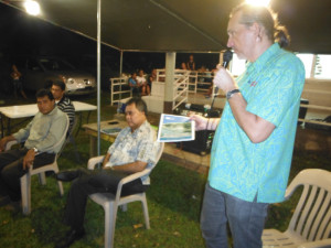
A new video showcasing some of the climate change adaptation activities on Kosrae was launched in Samoa at the Pacific Climate Change Roundtable on Tuesday 12 May.
A new video showcasing some of the climate change adaptation activities on Kosrae was launched in Samoa at the Pacific Climate Change Roundtable on Tuesday 12 May.
Over the night of Friday 8th and Saturday 9th May Tropical Depression 07W / Tropical Storm Dolphin caused wind damage to vegetation and light structures across Kosrae, as well as flooding of property in Utwe due to large swell. Some initial photographs of the damage are available here.
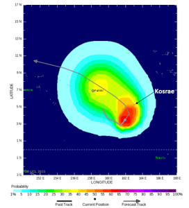
Over the night of Friday 8th May and through Saturday 9th May Tropical Depression Seven is going to pass close to the west of Kosrae. The current wind patterns on Friday evening are shown below.
The tropical depression has been tracking east to the south of Kosrae and is forecast to bend north and then head west towards Pohnpei. It is unlikely to increase to a tropical storm until it is well west of Kosrae. There is a medium (up to 50%) chance of winds reaching tropical storm strength (wind speeds of 62-88 km/hr) at Kosrae over the next 48 hours.

Likelihood of tropical storm strength winds over the Friday (8th) and Saturday (9th) May. Sourced from www.tropicalstormrisk.com
Damage is likely to be reasonably minimal typically to only the flimsiest lean-to type structures. Unsecured light signs blown down and unsecured corrugated iron blown about. Minor damage to banana trees and near-coastal agriculture, primarily from salt spray. Some small dead limbs, ripe coconuts, and dead palm fronds blown from trees. Some fragile and tender green leaves blown from trees such as papaya and fleshy broad leaf plants.
Wave conditions are likely to be highest off the south (Utwe) and south-east (Malem coasts. Seas are likely to be rough with higher than normal wave breaking on the fringing reef. Any wave overwash, flooding and damage is likely to occur around high tides which are at 5:47 pm on Friday and 6:04 am on Saturday. High tide levels are not particularly high, currently dropping from the spring tides in the middle of the week.
Sea levels in the western Pacific are continuing to fall as El Nino conditions continue to threaten with about a 45% chance of El Nino occurring between March and May increasing to around 60% in June to April.
Sea level anomaly forecasts are current mixed with the PEAC forecast for March to May indicating a sea level that is around 2 inches (5 cm) higher than normal (normal being the average sea-level between 1983 -2001) and the Bureau of Meteorology model forecast which is indicating for the Kosrae region a fall in sea level of around 4 inches (10 cm) relative to normal (which is taken as the average sea level between 1981-2010). Irrespective of the different baseline there is still a divergence in the sea-level forecasts reflecting the rapidly changing sea-level anomalies that have been occurring over the last few months.
For the April and May tide calendars a value of 2 inches (5 cm) below normal has been assumed. This, along with the lower high tides get at this time of year should reduce the likelihood of coastal flooding occurring due to high tides. However if large waves, swell or strong winds occur at the same time as high tide, flooding of low-lying land and overwashing of exposed sections of the circumferential road will occur.
The tide calendars for April and May (tide prediction + seasonal sea-level forecast), are now available in both English and Kosraean. These can be downloaded below:
Kosraen: Eprel-2015 | Mei-2015
Copies of the tide calendars can also be obtained from the KIRMA office in Tofol.
Sea levels in the western Pacific have been falling over the last few months which is in keeping with the El Nino conditions that are developing. El Nino tends to result in lower sea levels on Kosrae. It is likely that tide levels on Kosrae will be close to normal over the next three months
However, the December to February period is when large tides occur on Kosrae. The largest king tides will be experienced between:
Given the lower sea-levels that are occurring at present it is unlikely that these tides will be quite as high as was experienced in January/February last year. However if large waves, swell or strong winds occur at the same time as high tide, flooding of low-lying land and overwashing of exposed sections of the circumferential road will occur.
The tide calendars for December, January and February (tide prediction + seasonal sea-level forecast), are now available in both English and Kosraean. These can be downloaded below:
English: December-2014 | January-2015 | February-2015
Kosraean: Tisampuh_2014 | Janwuri-2015 | Febwuri-2015
Copies of the tide calendars can also be obtained from either the KIRMA office or PACC office in Tofol.
The latest Pacific ENSO Update bulleting whas just been released and can be downloaded from http://www.prh.noaa.gov/peac/update.php
The Kosrae information is summarised below:
The total rainfall for the first 9 months of 2014 was slightly below average at all Kosrae reporting sites. The monsoon trough extended to Kosrae during April, with accompanying heavy rains. An early appearance of the monsoon (i.e., westerly winds) is a typical sign of impending El Niño. During May and June, the monsoon trough weakened and winds became light easterly at Kosrae. Rainfall was near average to below average. During July, monsoonal westerlies returned, bringing abundant rainfall from its associated tropical disturbances. During August, there was another break in the monsoon across most of Micronesia as enhanced rainfall and tropical cyclone development shifted into the region of the ITCZ in the central and eastern Pacific. August was a very dry month on Kosrae. September continued the August dry spell, but the monsoon returned and helped spawn two tropical cyclones (Phanfone and Vongfong) that formed in the Marshall Islands and passed close-by to the north of Kosrae in their developmental stages on the 27th of September and the 2nd of October, respectively. Heavy rain showers were the only effects of these tropical cyclones on Kosrae. No reports of damaging sea inundation were received from Kosrae.
Episodes of unusual westerly winds will likely be experienced on Kosrae through mid-January. Rainfall totals for the remainder of 2014 should be near or slightly above average. Through January 2015, there remains an elevated risk of a tropical storm passing close to Kosrae. Looking forward into early 2015 (January through May), there is a risk of drier than average conditions; however in the absence of a moderate or strong El Niño, we do not expect dryness to be severe.
Predicted rainfall for Kosrae State from October 2014 through September 2015 is:
Mean sea levels have continued to fall over much of the western Pacific, particularly to the north and west of Kosrae (see plot below) and it is likely that tide levels will be close to normal over the next three months.
There are unlikely to be significant high tides causing coastal flooding during September and October (except if storms or large swell occurs). More significant high tide levels will begin to be experienced again in November, particularly around the 7-8 and 23-24 of November. However, these are unlikely to be as high as was experienced at this time last year.
The tide calendars for September, October and November (tide prediction + seasonal sea-level forecast), are now available in both English and Kosraean. These can be downloaded below:
English: September-2014 | October-2014| November-2014
Kosraean: Septempuh-2014 | Oktopa-2014 | Nofuhmpuh-2014
Copies of the tide calendars can also be obtained from either the KIRMA office or PACC office in Tofol.
Seasonal forecasts (for next few months) for sea levels were not available at the start of September from the Pacific ENSO Applications Centre (PEAC). Rather forecasts of sea level variability over the coming months from an interactive map from the Australian Bureau of Meteorology was used. The figure below shows the sea level anomaly over the September to November period (relative to the 1981-2010 average) over the western Pacific. Over the next 3 months, this suggests a sea-level anomaly in the region around Kosrae of around 0 to 5 cm (0 – 2 inches) above the 1981-2010 average.
Seasonal forecasts (for next few months) for sea levels were not available at the start of June from the Pacific ENSO Applications Centre (PEAC). However, mean sea levels have been falling and it is likely that tide levels will be close to normal over the next three months.
For the tide calendars for June, July and August (tide prediction + seasonal sea-level forecast), are now available in both English and Kosraean. These can be downloaded below:
English: June-2014 | July-2014 | August-2104
Kosraean: Jun-2014 | Julae-2014 | Okos-2014
Copies of the tide calendars can also be obtained from either the KIRMA office or PACC office in Tofol.

Fenno Brunken of the GIZ regional programme Coping with Climate Change in the Pacific Island Region (CCCPIR) at the launch of the Kosrae Shoreline Management Plan during the Micronesian Environment Forum. Seated are the Honourable Lyndon Jackson, Governor of Kosrae, Robert Jackson, Director of KIRMA and Simpson Abraham, FSM PACC Coordinator.
The updated Kosrae Shoreline Management Plan was formally launched on the 21 March by the Honourable Lyndon Jackson, Governor of Kosrae, during the Micronesian Environment Forum.
The Shoreline Management Plan was an initiative in 2000 of the Development Review Commission (now Kosrae Island Resource Management Authority). This revision of the Shoreline Management Plan incorporates new information of coastal hazards, climate change and what it means for coastal areas on Kosrae and the communities and development located there. It sets out a pathway over the next one to two generations to create a more resilient society and one that provides a secure foundation for our future generations to better manage the ever increasing impacts of climate change and sea-level rise on Kosrae.
The plan has been develop as a collaborations between the five village communities, Municipal staff, KIRMA, the FSM PACC Office, and various Government offices on Kosrae with technical support and guidance provided by the National Institute of Water & Atmospheric Research Ltd (NIWA) and Secretariat of the Pacific Community Applied Science and Technology Division (SPC-SOPAC) The revision of the plan was funded through support by the Deutsche Gesellschaft fur Internationale Zusammenarbeit (GIZ) regional programme Coping with Climate Change in the Pacific Island Region (CCCPIR).
 The full Kosrae Shoreline Management Plan can be downloaded by clicking on the image to the left (6Mb pdf file).
Seasonal forecasts (for next few months) for sea levels and rainfall for Kosrae produced by the Pacific ENSO Applications Centre (PEAC) suggest that:
Further information is available from the Pacific ENSO Update newsletter.
The tide calendars for March, April and May (tide prediction + seasonal sea-level forecast), are now available in both English and Kosraean. These can be downloaded below:
English: March-2014 | April-2014 | May-2014
Kosraean: Marj-2014 | Eprel-2014 | Mei-2014
The three month seasonal forecast of highest daily tides and dates of extremely high tides is only available in English: Mar-May-2014
Copies of the tide calendars can also be obtained from either the KIRMA office or PACC office in Tofol.
In addition to the Pacific ENSO Applications Centre, forecasts of sea level variability over the coming months are also available as an interactive map from the Australian Bureau of Meteorology. The figure below shows the sea level anomaly over the March to May period (relative to the 1981-2010 average) over the western Pacific. Over the next 3 months, this suggests a sea-level anomaly in the region around Kosrae of between 5 cm to 10 cm (2-4 inches) above the 1981-2010 average.