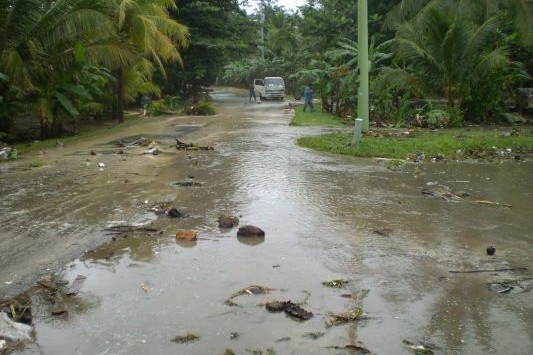
The north and east coast of Kosrae experienced significant damage due to coastal flooding over the 8 and 9 of December 2008.
The coastal flooding was due to weather conditions well to the north of Kosrae creating large swell waves that moved south across the Pacific. Considerable damage was also experienced on the eastern coast of Majuro, other parts of the FSM and Kiribati, and a couple of days later the east coast of New Ireland, outer islands of Bougainville, Manus and parts of East Sepik in Papa New Guinea resulting in over 50,0000 people being displaced, as the swell waves moved south.
The swell waves reaching the north coast of Kosrae were on average around 6 to 8 feet high, with some up to 11 to 12 feet. However, the height of the waves breaking on the edge of the reef off of Tafunsak would have seemed much larger. The period of the swells waves, or the time between each wave crest, was very long around 13 to 16 seconds.
When swell waves break on the edge of the reef, they pump water on to the reef flat resulting in water levels over the reef flat being higher than normal. If the wave period is long, more water is pumped on to the reef resulting in higher water levels over the reef. This is known as wave set-up. With higher water levels on the fringing reef this allows larger wave heights to travel over the reef and reach the shoreline. The long time between each wave crest also increase the height waves run-up over the beach or coastal defence and land behind the beach causing more flooding than normal. The run-up, overtopping and flooding of the coastal areas along Tafunsak and other north facing coasts is natural and would be expected under wave conditions such as these.

Extent of coastal inundation experienced along the Tafunsak coastline, 8 December 2008 (Image created by Blair Charley, KIRMA)
However, the damage on Kosrae could have been much worse. The wave conditions occurred four or five days before spring tides. If these waves had coincided with a high spring tide as would be occurring the following weekend, the damage would have been much greater.
These large swell events, due to particular storm conditions well north of Kosrae, appear to happen every now and again. In December 1969 two storms in the North Pacific between 40ºN and 50ºN resulted in swell waves of between 4 m and 6 m (12 to 18 ft) travelling over 7000 km to the south. This affected the north coast of Kosrae as well as the northern coasts of islands in Kiribati, Tuvalu, Samoa, Cook Islands and Tahiti. Similar wave events may have damaged the old school buildings in Walung in 1979, and caused damage at Wot over 13-14 October 1961.
These wave conditions, and the damage that has been caused, has nothing to do with climate change. These storm conditions happen from time to time and will result in damage to property and roads that are located too close to the coastline. However, it does emphasis just how vulnerable much of the property and infrastructure located close to the coastline is on Kosrae is. As the influence of climate change increases, damage to property and infrastructure located too close to the coast will become more frequent.
Further Information
Ramsay, D. (2008). Coastal damage on the north coast of Kosrae 8 December 2008. 9 December 2008.
PACNEWS (2008) Tidal surges cause massive damage in FSM 19 December 2008.
Hoeke, R. et al (2012) Widespread inundation of Pacific Islands triggered by distant source wind-waves.


